Okwu mmalite
This manual provides detailed instructions for the operation and maintenance of your Garmin GPSMAP 78sc 2.6-Inch Waterproof Marine GPS and Chartplotter. The GPSMAP 78sc series is designed for recreational navigation, featuring a bright 2.6-inch LCD color display, built-in basemap, and a high-sensitivity GPS receiver. All models are waterproof to IPX7 standards and float in water, making them suitable for boating and watersports. Key features include a built-in microSD card slot for additional maps and a dedicated Man Over Board (MOB) button.
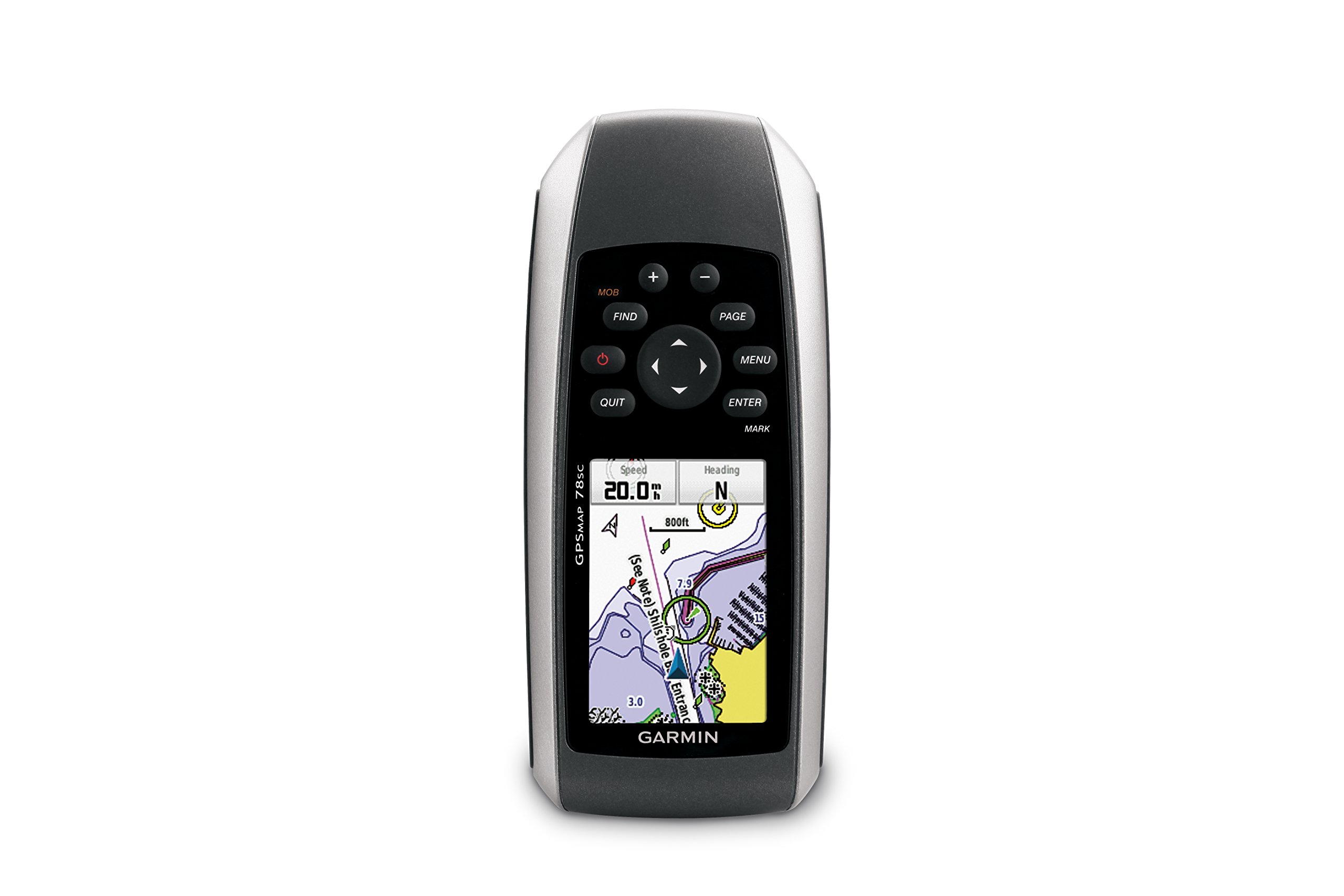
Foto 1: N'ihu view of the Garmin GPSMAP 78sc handheld marine GPS and chartplotter.
Ngwaahịa gafereview
Akụkụ ndị bụ isi:
- Marine-friendly handheld with high-sensitivity GPS receiver and 2.6-inch color TFT display.
- Waterproof to IPX7 standards; floats in water.
- Built-in BlueChart g2 U.S./Bahamas coastal charts with shorelines, depth contours, navaids, harbors, marinas, and more.
- Built-in 3-axis tilt-compensated electronic compass and barometric altimeter for heading, altitude, and weather information.
- Wireless sharing of waypoints, tracks, routes, and geocaches with other compatible devices.
Kedu ihe dị na igbe:
- GPSMAP 78sc device
- eriri nkwojiaka
- eriri USB
- Akwụkwọ ntuziaka

Ọgụgụ 2: N'akuku view of the Garmin GPSMAP 78sc, highlighting its button interface.
Vidio ngwaahịa:
Garmin GPSmap 78 handheld GPS Overview
Vidiyo a na-enye nkọwa zuru okeview of the Garmin GPSMAP 78 handheld GPS, demonstrating its features and design.
Ngwaahịa gafereview Vidiyo
A concise product overview video from the seller, highlighting key aspects of the device.
Melite
1. Ịwụnye batrị:
The GPSMAP 78sc operates on two AA batteries (not included). To install:
- Chọta mkpuchi nke batrị n'azụ ngwaọrụ.
- Twist the D-ring counter-clockwise to unlock and remove the cover.
- Insert two AA batteries, ensuring correct polarity (+ and -).
- Replace the cover and twist the D-ring clockwise to secure it.

Ọgụgụ 3: Azụ view of the Garmin GPSMAP 78sc, illustrating the battery compartment.
2. Ịgbanwu/ Gbanyụọ:
Pịa ma jide Ike button (located on the left side) to turn the device on or off. A short press will adjust the backlight.
3. Initial Settings:
Upon first use, the device may prompt you to set language, time zone, and other preferences. Follow the on-screen instructions using the directional pad and Banye bọtịnụ.
Na-arụ ọrụ
Navigation Basics:
- Isi menu: Pịa MENU button twice to access the main menu.
- Bọtịnụ ibe: Pịa IHE to cycle through the main pages (Map, Compass, Trip Computer, etc.).
- Mpempe akwụkwọ ntuziaka: Use the directional pad to scroll through menus, pan the map, or adjust settings.
- Tinye bọtịnụ: Pịa Banye to select an item or confirm an action.
- QUIT Button: Pịa Kwụsị to return to the previous page or cancel an action.
Creating Waypoints:
To mark your current location as a waypoint:
- Pịa MAKA bọtịnụ.
- Edit the waypoint name, symbol, and coordinates if desired.
- Họrọ Emechaala or Chekwa to store the waypoint.
Man Over Board (MOB) Function:
In an emergency, press the MOB button to immediately mark the current location and initiate navigation back to that point. This feature is critical for safety in marine environments.
Nlekọta
Na-ehicha ngwaọrụ:
Jiri akwa hichaa ngwaọrụ dampened with a mild detergent solution. Dry thoroughly. Avoid using abrasive cleaners or solvents that could damage the device's finish or screen.
Nlekọta batrị:
Always use fresh, high-quality AA batteries. If the device will not be used for an extended period, remove the batteries to prevent leakage and corrosion.
Mmelite ngwanrọ:
Periodically check the Garmin website for software updates to ensure optimal performance and access to the latest features. Updates can typically be installed by connecting the device to a computer via the USB cable.
Nchọpụta nsogbu
Ngwaọrụ anaghị agba ọkụ:
- Gbaa mbọ hụ na etinyere batrị nke ọma yana chajịkwa ya nke ọma.
- Try new batteries.
- Lelee kọntaktị batrị maka corrosion.
Ihe ngosi GPS adịghị mma:
- Gbaa mbọ hụ na ngwaọrụ ahụ nwere nke doro anya view nke elu-igwe.
- Avoid areas with tall buildings, dense foliage, or other obstructions.
- Allow sufficient time for the device to acquire satellites, especially after being off for a long period.
Ihuenyo anaghị anabata:
- Perform a soft reset by removing and reinserting the batteries.
- Hụ na ihuenyo ahụ dị ọcha ma ghara inwe ihe ruru unyi.
Nkọwapụta
| Njirimara | Nkọwa |
|---|---|
| Ụdị | Garmin |
| Aha Nlereanya | gps map |
| Nọmba nlereanya | 010-00864-02 |
| Nha ihuenyo | 2.6 sentimita asatọ |
| Ụdị ngosi | LCD |
| Mkpebi | 160 x 240 pikselụ |
| Ngosi nke enweghị mmiri | IPX7 (floats) |
| Ndụ batrị | 20 Hours (typical) |
| Ụdị batrị | Batrị 2 AA (anaghị etinye ya) |
| Ike Nchekwa ebe nchekwa | 1 GB |
| Compatible Flash Memory Type | microSD |
| Sistemụ ịnyagharị Satellite akwadoro | GPS |
| Atụmatụ pụrụ iche | Rugged case, Barometric altimeter, Garmin Connect compatible, Electromagnetic compass, Garmin HotFix, Custom POIs, Automatic routing, Hunt/fish calendar, Geocaching, Photo navigation |
| Akụkụ akụkụ L x W x H | 2.6"L x 1.2"W x 6"H |
| Ibu Ibu | 7.7 ounces |
Akwụkwọ ikike na nkwado
The Garmin GPSMAP 78sc comes with a 1 Year Limited Warranty. For detailed warranty information, product support, or service inquiries, please refer to the official Garmin website or contact Garmin customer service directly. The included manual also contains contact information and further support resources.